
Description
Day Wise Tour Plan
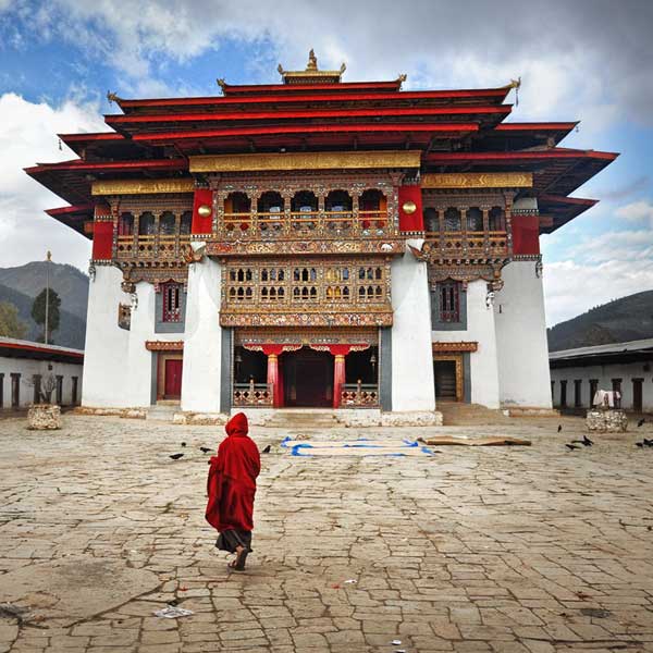
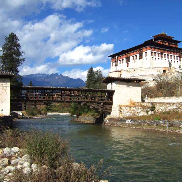
On arrival at Paro international airport by Durk /Tashi Airlines, after visa formalities and immigration you will be received by Bhutan Travel Tag representative and proceed toward your hotel. After refreshment you can explore Paro valley to understand Bhutanese culture & Tradition. You may also visit to Paro Dzong, one of Bhutan’s most impressive and well-known dzong, and the finest example of Bhutanese architecture.
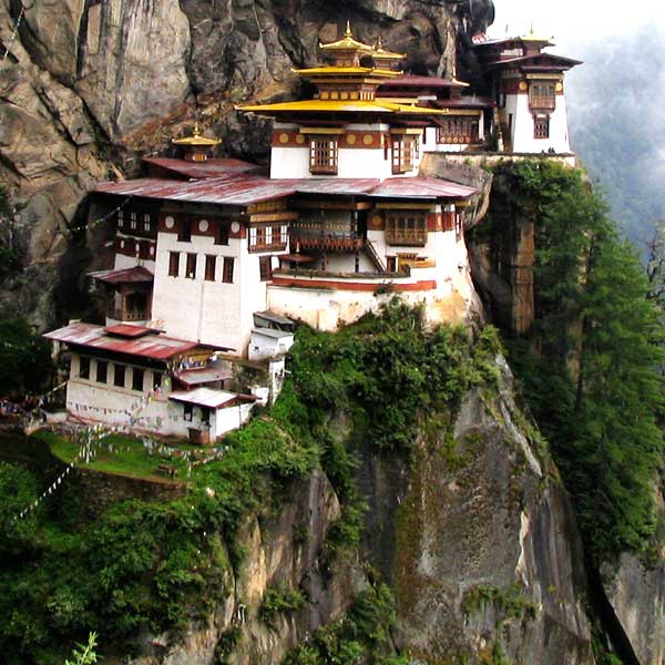
Today you will go for a hike Tiger’s nest monastery, it is very beautiful & moderate hike in Paro, This may take 2-3 hours through Pine forest. It is believed that the Buddhist saint Padmasambhava came in the 7th century on a flying tigress and meditated in a cave for 3 months. The demons were subdued who were trying to stop the spread of Buddhism and converted the Paro valley to Buddhism. During the end of the 17 century, a monastery was built on the spot where the saint meditated and it is a pilgrimage site for every Bhutanese to visit once in their life time. After coming down we will drive to hotel in Paro.
Today we will drive to Drugyel Dzong, this is the oldest Dzong (fort) where LunanaSnowman trek start, but we will continue up the extended road to the Army Camp, and the start of our trekking route. Heading up the Paro Chhu river valley, the trail passes the small settlements where we see excellent examples of Bhutanese farmhouses, and then through a forest to ‘Pine Camp’ (3000m).
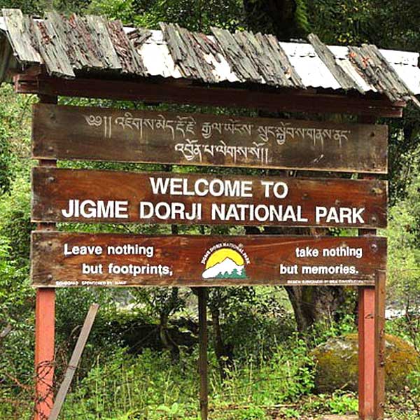
Leaving Pine Camp the trail continues upriver and the route winds in and out of rhododendron and blue pine forests. We are now in Jigme Dorji National Park, the wild life century so keep your eyes open for wildlife and changes in vegetation as we continue to climb in elevation. Tonight we camp in Thangkthanka (3520m)
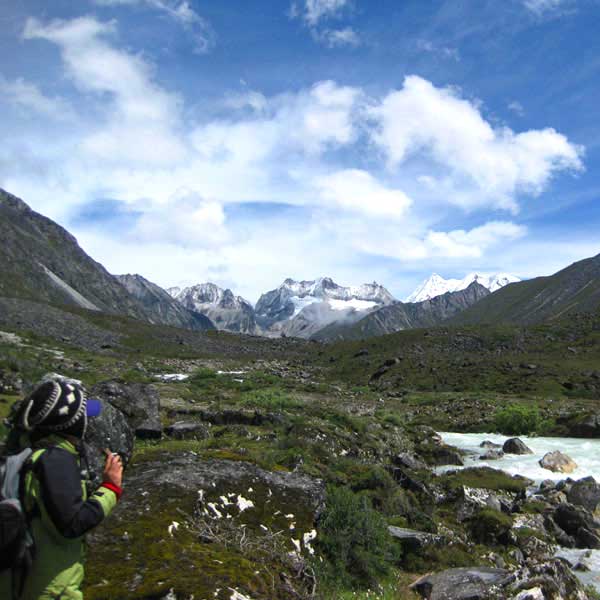
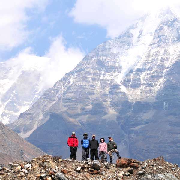
This morning we leave the tree line and head into the high mountains. At the halfway point of our hike, we cross Tengethang, a winter home of the migratory yak herders. Arriving at Jangothang (4040m), we can watch the sun set on Mt. Jhomolhari (7314m) and Mt. Jichu Drake (6989m).
The first of our acclimatization days, we have many day-hiking options. The first is a three to four hour excursion up the ridge to the north for great views of Jichu Drake. The second is to hike up towards the head of the valley in the direction of Jhomolhari. The third is a trek up the main valley towards the last house and onward toward Jichu Drake, this gives a great view of where we will be going in the next few days. The final alternative is a fishing expedition to Tshophu, a high-altitude lake about a two hour hike away.
Heading uphill from Jangothang we cross the first of many major passes. The Nyile La pass at 4890m (16,135 ft) is about a four hour ascent. Descending the other side we will encounter sparce juniper and rhododendron and pass many yak herder camps. From this area on we start to see herds of blue sheep. Arriving in Lingshi we set up camp at 4150m.
This morning we will visit Lingshi Dzong, it was used in the past to control travel between Tibet and Bhutan. Since today’s hike will not be as long, the pace will be more relaxed. Upon reaching the camp at Chebisa (3850m), we will visit Chebisa village and see a slice of Bhutanese culture in village life.
Crossing the Gombu La pass at 4350m, we descend into a rhododendron filled valley, and continue past some yak herder camps to Shakshepasa where we camp at 3980m. Sometimes we continue on to a bigger (flatter;) camp 1.5 hours further along the trail to make the next day a little shorter.
Today early morning start will get us on the way to Jhari La pass at 4747m. Decending to Tsharijathang, the valley where herds of Takin (the national animal of Bhutan) are normally seen. From here we climb to our camp at Robluthang at 4160m.
Starting early a strenuous hike leads to the Shinge La pass at 5005m (16,650 ft). Descending to Limithang we’ll see Mt. Gangchenta (6840m) and the glacially carved Gangchhenta valley. Gangchhenta means Great Tiger Mountain. We camp at 4140m.
A shorter hike follows a trail in and out of a heavily wooded, uninhabited valley. Climbing up out of the forests we will be rewarded with some great views of Gangchhenta and Masang Gang (7165m) mountains. We camp at Laya at 3840m.
Staying in Laya for the day we will get a chance to see the village with its community school, hospital, archery field and the first shop since the Paro Valley. Laya is a unique village of about 800 people with their own language, customs and distinct dress. The women keep their hair long and wear peculiar conical bamboo hats with a bamboo spike at the top. They wear a lot of silver jewellery on their backs, on many women this display includes an array of teaspoons.
The trek leads gradually downhill to the Lunana trail junction, and then makes a gradual climb to the camp through a forest of conifers, maple and rhododendron. The trail improves and becomes wider as we climb out of the river valley. We camp at Rodufu near a small stream at 4160m.
It is a long hike, first crossing the Tsimo La pass at 4950m (16,200 ft). Descending to Narethang we pass some dwarf rhododendron and hike in the shadow of GanglaKarchung peak (6395m). We camp at 4900m.
Climb to Karchung La pass at 5240m (17,187 ft) and down to the glacial lakes that are the source of the Tang Chhuriver. Above the lakes are the mighty peaks of Jejekangphu Gang (7300m) and Tsenda Kang (7100m). We camp at Tarina, 4020m.
The walk leads down through conifer forests, following the upper reaches of the Pho Chhuriver. The trail then climbs over a ridge and drops to the village of Woche at 3940m (13,000 ft). The trek has now entered the Lunana region. We often continue on about an hour past Woche to a spectacular campsite below the Keche La pass
It’s a gradual climb from Woche to the campsite below the pass, and then gets steeper on the section up to the Keche La, at 4580m, after which it drops steeply to Thega village our usual lunch spot. The afternoon hike continues along a beautiful river valley past spectacular waterfalls to Lhedi village where we camp at 3600m. Sometimes we continue on about an hour or so beyond Lhedi village to a lovely campsite.
The trail climbs gradually following the main source of the Pho Chhu to Chozo village. At the small Chozo Dzong there are some lay monks. Above Chozo the valley opens as we approach Thanza village near the foot of 7100m ZogophuGamp, which is also known as Table Mountain. We camp at Thanza, 4080m.
This day is a fantastic opportunity to interact with the hospitable local villagers, and explore the beautiful surrounding area, our farthest point in the Lunana valley. Otherwise you can relax around camp and rest up for some of the tough days ahead. As Thanza is sometimes a transfer point for horses and yaks, it is sometimes necessary to have a day here for our staff to ensure all the necessary yaks are rounded up by the local herders who do not operate on ‘Western time’! Please note: Assuming everyone in the trekking party has acclimatized properly up to this point, and our horse/yak logistics are smoothly in place, we may only spend the morning in Thanza, and leave for our campsite up the valley at Danji in the afternoon in order to save the rest day in case it is required later in the trek due to altitude or weather-related concerns while crossing the Rinchen Zoe pass out of Lunana.
Today is a relatively short, although somewhat steep, climb to a campsite called Danji, part way up to the Jaze la pass. It will allow us to have some extra time in the morning and make a later start. The camp is around 4600m, with spectacular views of snow-capped peaks! It is an important acclimatization spot.
The first part of the day involves a climb up over three false summits to Jaze La pass at 5050m (16,570ft). From the pass it is a short downhill trek to the campsite at the lake of Tso Chena at 4800m. Keep your eyes open for blue sheep during the hike.
The trail has a series of gradual ups and downs between the snow-capped peaks and across the Loju La pass at 4940m before descending to camp at Jichu Dramo at 4880m.
We start with a hard climb to Rinchen Zoe La pass at 5290m, the highest on the trek. It is then all downhill to Chukarpo, which is just above the tree line at 4950m.
It is a long mostly downhill walk along the river, followed by a climb up to the Um So lake at 4230m. In this lake PemaLingpa found a number of religious treasures. Continuing downhill we camp by the lake of ThampeTso at 4200m.
It is a short walk to the base of Thampe La and a steep climb to the pass at 4580m. The trek is then all downhill through rhododendron bushes to the yak pasture of Maurothang where we camp at 3550m.
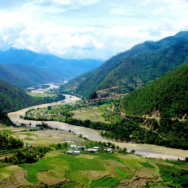
On our final day of trekking we descend through a beautiful valley to the lovely village of Sephu where the new road-head beyond NikachuChazam continues to push up the valley to the upper part of the village. From there, if time permits, we will drive east to Trongsa. This beautiful Dzong is the center of the region of Bhutan called “Bumthang”. The Trongsa Dzong is one of the most impressive in the kingdom, and can be seen from a great distance in its strategic position high above the MangdeChhuRiver. In the late-afternoon/early evening, we have a spectacular 3-hour drive back west across the mountains to Punakha. We stop along the way at Chendebji to visit the ChendebjiChorten, patterned after Swayambhunath in Kathmandu and built in the 19th century by Lama Shida from Tibet. We also stop at the top of the Pele La pass (3400m). Overnight hotel in Punakha.
This morning we will visit PunkahaDzhong, it is located at river bank and most important Dzong in Bhutan, after that after lunch we will move towards Paro via Thimphu sightseeing, like Buddha point, takin Preserve national park, etc. and stay hotel in Paro.
This morning we’ll have time for one last walk through town before saying our goodbyes and heading to the airport for the Druk/ Tashi Air flight out of Bhutan.